What Came Before the South Village
In honor of South Village Month, we are turning to the Sullivan-Thompson Historic District designation report to explore what this neighborhood was like before it was known as part of the South Village.
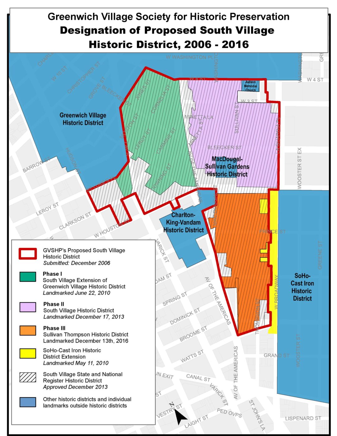
The area south of Washington Square Park and West Fourth Street and east of Seventh Avenue, now often referred to as the South Village, was left out of the Greenwich Village Historic District designated in 1969, leaving many of the neighborhood’s most charming buildings and culturally significant sites vulnerable to demolition. Yet the South Village has always been an essential part of Greenwich Village’s story; one could reasonably argue that these streets should have been included in the original 1969 designation. Bleecker, Carmine, MacDougal, Sullivan, Thompson, Downing, Cornelia, Jones, Minetta Street, and Minetta Lane are deeply tied to some of the Village’s and the city’s most significant historic moments and together formed the heart of the Village’s Italian immigrant community.
But long before the South Village became a dense, mixed-use, working-class neighborhood, it was known as Sapokanican, a Lenape settlement whose name roughly translates to wild tobacco. After Dutch colonists arrived in Manhattan in 1625 and Peter Minuit of the Dutch West India Company believed he had purchased the island from the Lenape for goods valued at sixty guilders in 1626, the area’s marshland was transformed to meet the needs of European settlers.
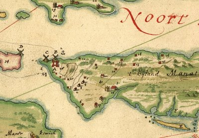
Beginning in the 1640s, several Black soldiers and formerly enslaved men (and one woman) were granted freedom and land here. Among them was Cleyn, also known as Little Antonio, an Angolan who was among the first enslaved people brought to New Amsterdam. He received six acres of land that encompassed much of the northern portion of today’s Sullivan Thompson Historic District, including most of the area north of Prince Street and roughly half the block bounded by Prince, Spring, MacDougal, and Sullivan Streets. Nearby parcels belonged to Pieter San Tomé and Gracia D’Angola, also formerly enslaved individuals who briefly shaped the early landscape of the neighborhood.
But their ownership did not last long. In 1664, England seized New Amsterdam and renamed it New York. Shortly after, the British relegated free blacks to alien status and denied them the privileges granted to white settlers, including the right to own property. Consequently, the land owned by Black farmers were back in the hands of the wealthy, white landowners who built plantations and country retreats. By the end of the seventeenth century, Nicholas Bayard, the nephew of Peter Stuyvesant, controlled much of the land that now makes up the Sullivan Thompson Historic District. After Bayard’s death in 1707, his family retained ownership and, following a familiar Lower Manhattan pattern, surveyed and subdivided the property into building lots during the eighteenth century, laying the groundwork for future urban development.
In 1775, the Bayard estate was divided into East and West Farms by Great George Street, which later became Broadway. Development proceeded more rapidly on the western side, prompting the Bayard family to commission surveyor Theodore Goerck in 1788 to map out prospective streets and building lots. Goerck’s plan introduced MacDougal, Sullivan, Thompson, Prince, and Houston Streets, establishing the framework of what would become the Sullivan Thompson Historic District. By the turn of the nineteenth century, much of the former Bayard estate had been acquired by Vice President Aaron Burr.
Concurrently, the southern end of today’s historic district remained shaped by water. The land, known as the marshy Lispenard Meadows, lay nearby and was fed by streams connecting the Collect Pond to the Hudson River. Throughout the late eighteenth century, city officials and landowners debated how to drain the Collect, eventually converting Lispenard Meadows’ drainage ditch into an eight-foot-wide canal in 1808. Two blocks south of the district, this canal was covered over in 1819 and transformed into what is now Canal Street.
Like much of Lower Manhattan, the South Village experienced a dramatic population surge in the mid-nineteenth century as immigration to New York City soared. Early residents were predominantly Irish and German, joined by sizable populations from France, England, and other Western European countries. The blocks that now comprise the Sullivan Thompson Historic District were also home to a significant Black population, both of people born here in New York and those who migrated here from other parts of the country. Following the opening of the Erie Canal in 1825, New York rapidly emerged as the nation’s commercial capital. Federal and Greek Revival style rowhouses rose across the neighborhood during this boom, many of which survive today in conditions ranging from nearly pristine to heavily altered, with most falling somewhere in between.
By the late nineteenth century, the area had become a long-standing ethnic enclave shaped primarily by working-class immigrants, most prominently though not exclusively Italian Americans, who were joined in the mid-to-late 20th century by a significant number of Portuguese immigrants, who largely attended the local St. Anthony of Padua Church (named, serendipitously, for a Portuguese-born Franciscan friar who did much of his work in Italy). Unlike the neighboring West Village, the South Village’s architecture reflected its working-class character through converted rowhouses, tenement buildings, and layered streetscapes that tell a story of adaptation, resilience, and community. Long before it had a name of its own, the South Village was already absorbing change while holding fast to its history. South Village Month offers an opportunity to celebrate not just what the area is today, but the many communities, layers, and histories that have defined it from the very beginning.